Welcome aboard the Crescent®! The Crescent takes you on a journey through the Northeast cityscapes, the shining Blue Ridge foothills, historic Civil War battlefields, the heart of the American South and the shimmering Louisiana bayou country. On board, you will experience the comfort and relaxation of train travel while witnessing unique scenery. We are happy to have you aboard today and want to ensure your trip is everything you want it to be. If there is anything that can be done to make your trip more enjoyable, please do not hesitate to call on any Amtrak employee.
Numbers in yellow represent total miles remaining in the train's journey to New York City. For my trip the actual number is the number shown minus 91, the number of miles the train will travel after I leave it in Philadelphia.
Numbers in yellow represent total miles remaining in the train's journey to New York City. For my trip the actual number is the number shown minus 91, the number of miles the train will travel after I leave it in Philadelphia.
 NEW ORLEANS (1377 mi.) “America’s Most Interesting City” is also known as the Crescent City, ‘Nawlins, and the City that Care Forgot. Whatever you call it, it won’t be boring. The city mixes jazz, nightlife, world-class restaurants, antebellum architecture and a storied history – sufficient to satisfy varied tastes. The Crescent ends its trip at Union Station, next to the massive Louisiana Superdome, the largest fixed dome structure in the world and home to the New Orleans Saints of the NFL. Whether it’s a cruise on a grand Mississippi River paddlewheeler, a trip on the famed streetcars through the Garden District or a stroll through the Riverwalk shopping center, there is much to see and do here. New Orleans was the wealthiest and third most populous city in the U.S. in the mid 19th Century. Today, from the renowned French Quarter and Bourbon Street to famous St. Charles Avenue, home to Tulane and Loyola Universities, New Orleans is one of the top ten most visited cities in the U.S.
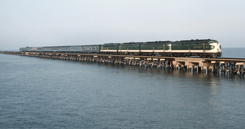 Lake Pontchartrain (1349 mi.) A 6.2-mile trestle carries the Crescent across the 630-sq. mile lake, the second largest saltwater lake in the U.S. U.S. Route 11 and Interstate Highway 10 cross on the adjacent causeways. Before we cross the lake, we pass a cemetery, note the above ground gravesites due to the low elevation of the land above the water table.
 SLIDELL (1342 mi.) Welcome to the heart of Bayou Country. Slidell was named for John Slidell, the one-time Confederate States of America commissioner to France and member of Congress. Founded in 1910, the town became a center for construction materials with both a lumber mill and a brickyard. In the 1960s, NASA opened several facilities in the area and Slidell’s population tripled during the next decade.
Mississippi/Louisiana State Line (1329 mi.)
 PICAYUNE (1324 mi.) was founded in 1904 and named after a Spanish coin that had historically been used by inhabitants of New Orleans. The landscape around here grows more subtropical. The city has become home to many who moved north from the Gulf Coast and New Orleans searching for a safer place to live after Hurricane Katrina.
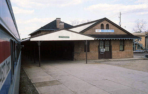 HATTIESBURG (1260 mi.) is another town that got its start due to the lumber industry and the railroad. The presence of several rail lines yielded the moniker the “Hub City.” The University of Southern Mississippi (where Brett Favre played), William Carey University and Camp Shelby, the largest National Guard training base east of the Mississippi River are located here. The Italian Renaissance style train station was restored and re-dedicated in 2007. Singer, songwriter, author and movie producer Jimmy Buffett played guitar here during his college years at Southern.
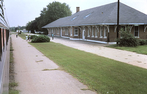 LAUREL (1231 mi.) proclaims itself to be “The City Beautiful,” referring to its oak tree lined streets and its early 20th century architecture. The city was founded in 1882 and grew as a rail center for shipping timber products from the area. Oil was discovered in the area in the 1950s and today there are over 150 companies providing services to oil and gas drillers. Laurel is the birthplace of Lance Bass, a member of the noted “Boy Band,” ‘N SYNC.
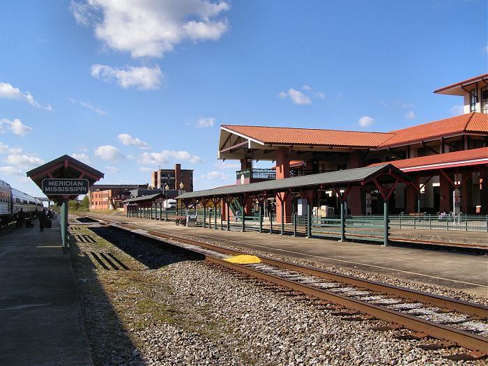 MERIDIAN (1175 mi.) was established in 1860 at a junction of several rail lines, but was burned to the ground a few years later at the conclusion of the Civil War. The railroads were rebuilt within a month and the town boomed. Industrial development fueled the town until the decline of its importance as a rail center in the 1950s. Efforts to revitalize downtown began in the 1990s, anchored by the historic reconstruction of the rail station as an intermodal terminal, served by the Crescent ®, intercity bus and local transit.
Alabama/Mississippi State Line (1155 mi.)
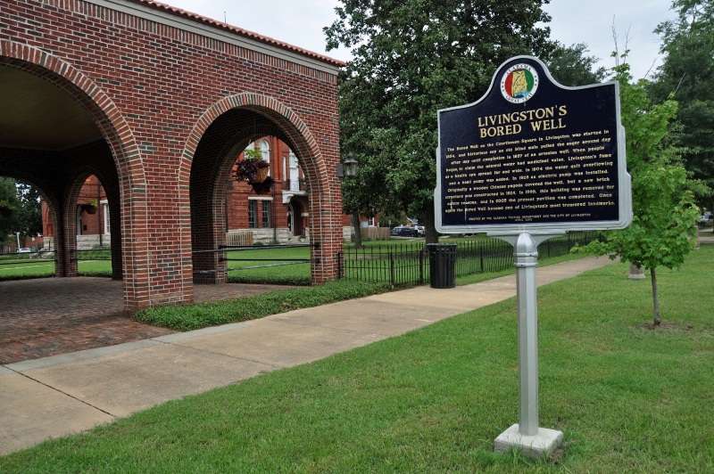 Livingston (1138 mi.) was named for statesman and jurist Edward Livingston. Nearby is Mannington Floors, manufacturer of residential and commercial flooring materials.
 Tennessee-Tombigbee Waterway (1127 mi.) The Tombigbee River, which we cross at the town of Epes, forms part of the Tennessee-Tombigbee Waterway that links the Tennessee River with the Mobile River and ultimately the Gulf of Mexico. The expenditure of $2 billion to construct the “Tenn-Tom” was very controversial. The waterway was completed in late 1984.
 Eutaw (1112 mi.) has 27 antebellum homes on the National Register of Historic Places. The site of prime cotton land, plantations flourished here prior to the Civil War. Nearby Greenetrack features thoroughbred horseracing, greyhound racing, bingo and gaming machines.
 Moundville (1093 mi.) Named for the above ground Indian mounds just north of the town is the Mound State Monument. The 20 mounds can be seen out the right side of the train.
 TUSCALOOSA (1078 mi.) is named for the Choctaw chieftain Tuskaloosa, who was defeated by Hernando de Soto in 1540. Between 1826 and 1846, the town was the capital of Alabama. The fifth largest city in Alabama, it is home not only to the University of Alabama but is also a center of industry, commerce, and healthcare. Mercedes Benz’ first North American auto manufacturing plant is located here. The Bama Theatre was one of the last of the traditional movie palaces built in the south, and was the only air conditioned building in town in 1938.
 Bryant-Denny Stadium, home of the Alabama Crimson Tide football team, is on the right as we approach Tuscaloosa. Known colloquially as “’Bama,” the university is the flagship school of the University of Alabama System. The football team has won 12 national championships, produced 18 hall-of-famers, including coach Paul “Bear” Bryant, and notched the most bowl appearances – and wins – of any college team.
 BIRMINGHAM (1023 mi.), Alabama’s largest city, is known as the “Pittsburgh of the South” and is named after one of the U.K.’s major industrial cities. Birmingham’s industries centered on iron and steel production, and the site of the city’s original railroad crossing is the only place worldwide where significant amounts of iron ore, coal and limestone – the raw materials for steel – can be found in close proximity. Over the course of the last century, the economy diversified. Today, banking, insurance, medicine, publishing and biotechnology maintain a strong presence. Actress Courtney Cox, singer Taylor Hicks and bandleader Lionel Hampton all hail from Birmingham.
 The Coosa River (988 mi.) has seven dams maintained by Alabama Power, making it the state’s most developed river. Hydroelectric power has proven valuable to the citizens of Alabama but costly to some species endemic to the main stem of the Coosa.
 ANNISTON (959 mi.) On the right side we can see the Lee Brass Foundry, one of the largest of its kind in the world. In 1917, the Army established a training camp at Ft. McClellan that today is used for Alabama National Guard training and a U.S. Homeland Security antiterrorism training unit. The Anniston Army Depot on the right is a major Army facility with primary missions including the repair of heavy tracked vehicles and storage of chemical weaponry, much of which has been destroyed. Examples of the tanks are visible from the train.
 Cheaha Mountain (945 mi.), visible on the left, is the highest point in Alabama. Bald Rock near the peak provides an impressive view from an overlook of the surrounding region. The mountain is part of the Talladega Mountains, the southernmost segment of the Blue Ridge
Time Change at this point you may adjust your watch as we cross the Central/Eastern time zone. If you are traveling east (north), set your watch ahead one hour; if you are traveling west (south), set your watch back one hour.
Georgia/Alabama State Line (924 mi.)
 Chattahoochee River (865 mi.) We cross the river as it passes through industrial sections of Atlanta. The name is believed to originate with the Creek Indian word for “painted rock” due to the colorful granite outcroppings along some segments. It displays much of the natural scenic beauty that runs through the city and is protected by watchdog groups.
 ATLANTA (859 mi.), financial and commercial capital of the New South, came into being as a rail terminus. Its Civil War importance as a military and railroad supply hub were portrayed in the 1939 film Gone With the Wind. The core was burned to the ground in 1864 by Union General Sherman as part of his March to the Sea. When it set about rebuilding, the railroad again played a vital role, shipping a local product known as Coca Cola. Today, Atlanta is a driving force of the South, undergoing a transition from a city of regional commerce to a city of international influence. Its Bank of America Plaza is the tallest building in the U.S. outside of Chicago and New York City. The city’s Georgia Dome, home of the Atlanta Falcons of the NFL, has hosted the Super Bowl twice. Atlanta features the world’s largest aquarium, Georgia Aquarium, opened in 2005. It is also a majorcable programming center, being home to CNN and The Weather Channel. Among Gamma World Cities in the U.S., Atlanta ranks third in the number of Fortune 500 companies headquartered within city boundaries, behind New York City and Houston.
 Oglethorpe University (852 mi.) is visible on the right; a private liberal arts college in Atlanta chartered in 1835 and named after the state’s founder, James Oglethorpe. Many of its campus buildings display distinctive Gothic revival architecture. The school is home to the International Time Capsule Society, a repository of time capsule projects worldwide.
 GAINESVILLE (810 mi.) is nestled in the foothills of the Blue Ridge Mountains. It is often called the chicken capital of the world because of its large number of poultry processing plants.
 TOCCOA (773 mi.) was the site of a paratrooper training base for the 101st Airborne Division, whose Easy Company was the subject of the HBO miniseries Band of Brothers. The town is the birthplace of actor DeForest Kelley, Dr. Leonard “Bones” McCoy on TV’s Star Trek; and Olympic gold medalist Paul Anderson, “the world’s strongest man.”
South Carolina/Georgia State Line (767 mi.)
 CLEMSON (739 mi.) is in the foothills of the Appalachian Mountains and home to Clemson University, which eight months of the year adds 17,000 additional residents to the town’s normal population of 12,000. The cultural center of the city, the university also houses Fort Hill, home of John C. Calhoun, one of only two men to serve as Vice President under two different Presidents, and only one of two men to have resigned the office.
 GREENVILLE (709 mi.) was once known as the “Textile Capital of the World,” but low wages and favorable tax benefits have more recently lured foreign companies such as Michelin. The city is also a respected medical center. Greenville has a thriving arts community; the Bi-Lo Center brings in national tours of many popular bands. Its Museum of Art houses the Andrew Wyeth Collection, which attracts scholars nationwide. Notable figures who were born in, lived in or worked in Greenville include Wayne Oates, the psychologist who coined the word “workaholic;” country music star Aaron Tippin; civil rights activist and two-time presidential candidate Jesse Jackson; and actress Joanne Woodward.
 SPARTANBURG (678 mi.) was established as a village in the 1780s and incorporated as a city in 1831. The downtown’s primary hub, Morgan Square, was named for Gen. Daniel Morgan, who commanded victorious American forces at the Battle of Cowpens nearby. A pivotal skirmish, its winning was dependent upon a local young woman, Kate Barry, who forewarned American troops of a British advance. Today, Spartanburg is home to the world headquarters of Denny’s restaurants and to a BMW auto manufacturing plant.
North Carolina/South Carolina State Line (644 mi.)
 GASTONIA (623 mi.) is part of the Charlotte metropolitan area and home of Parkdale Mills, the number one manufacturer of spun yarn in the world. Within the city limits is Crowders Mountain State Park, a popular destination for outdoor enthusiasts.
  CHARLOTTE (601 mi.), the Queen City, has emerged as a financial and healthcare hub. Its other nickname, “Hornet’s Nest,” is attributed to British General Cornwallis who, during the American Revolution, was bedeviled by the hostility of the local populace to British rule. Settled in 1755 at the intersection of two Native American trading posts, today’s Charlotte is the second largest banking headquarters in the country after New York City and the 19th largest city in the U.S. The city has one of the nation’s newest light rail transit systems. The NFL’s Carolina Panthers, founded in 1995, play home games at Bank of America Stadium. Charlotte’s 60-story, 871-ft. tall postmodern gothic tower that serves as the Bank of America’s Corporate Center is the tallest skyscraper between Philadelphia and Atlanta. Approximately 75% of NASCAR’s employees and drivers are based within two hours of downtown, and former Washington Redskins Hall of Fame coach and NASCAR championship team owner Joe Gibbs hails from Charlotte.
_station_front.jpg) SALISBURY (559 mi.) was the site of a Confederate prisoner of war camp that held up to 10,000 Union soldiers. The city is home to grocery store chain Food Lion and the hometown of the state’s former senior U.S. Senator and Secretary of Transportation, Elizabeth Dole.
SALISBURY (559 mi.) was the site of a Confederate prisoner of war camp that held up to 10,000 Union soldiers. The city is home to grocery store chain Food Lion and the hometown of the state’s former senior U.S. Senator and Secretary of Transportation, Elizabeth Dole. HIGH POINT (524 mi.), regarded as the “Furniture Capital of the World,” is also known for textiles. Its Thomas Built factory is one of only three large school bus manufacturers in the U.S. Here also resides one of the few Bentley dealerships in the southeast. The Angela Peterson Doll and Miniature Museum is one of the south’s largest, and its “World’s Largest Chest of Drawers” has been an iconic city symbol since 1926.
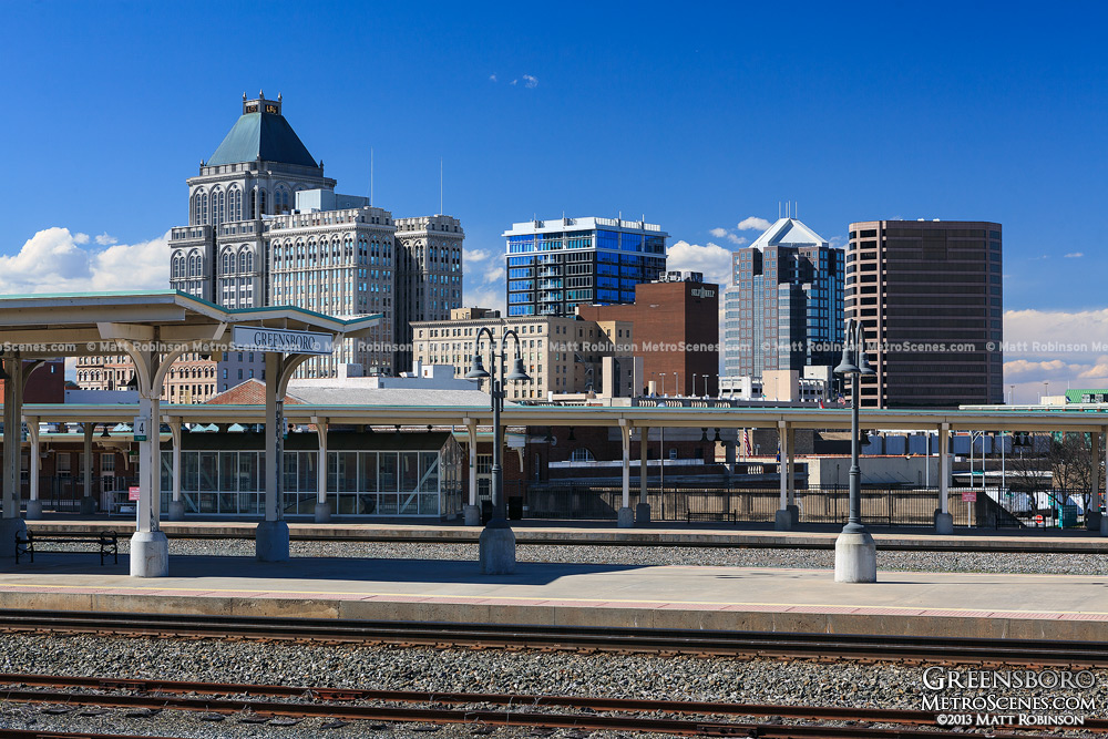 GREENSBORO (512 mi.) is the largest city in the “Piedmont Triad” metro region. It is named for Major General Nathanael Greene, whose forces inflicted heavy damage on the British Army of Lord Cornwallis during the Revolutionary War, ultimately leading to its surrender at Yorktown, Virginia. Although relatively undamaged by the Civil War, the city was the last meeting place of the entire Confederate government and the site where Confederate soldiers stacked their arms, received paroles and headed for home. Here was the first Woolworth’s lunch counter to be desegregated, which is now displayed at the Smithsonian in Washington. Prosperity was achieved through textiles, and the industry remains a strong presence today in this major textile headquarters city. Short story writer O. Henry and CBS news anchor Edward R. Murrow were born in Greensboro.
Virginia/North Carolina State Line (467 mi.)
 DANVILLE (461 mi.) was established in 1792 as Wynne’s Falls. The following year, the “world’s best tobacco market” was established and the village was renamed Danville. It briefly became the last capital of the Confederacy. The capital was housed in the palatial estate of Major William Sutherlin, which is now a museum of fine arts and history. One of the Confederacy’s leading generals, Danville native William Lewis Cabell, later became the mayor of Dallas, Texas, presiding over the considerable expansion and modernization of that city.
  LYNCHBURG (398 mi.) is known as the “City of Seven Hills.” Located near the geographical center of the state, it served as a Confederate supply base during the Civil War. Nearby is Appomattox Courthouse, where Gen. Robert E. Lee surrendered to Gen. Ulysses S. Grant to end the war. The first cigarette rolling machine was invented here and, thanks to the tobacco industry, the city was once the second wealthiest city in the country. Part of tobacco’s legacy is the remarkable architecture commissioned by wealthy residents. Thomas Jefferson’s country residence, “Poplar Forest,” is located nearby.
 CHARLOTTESVILLE (337 mi.) has been named best place to live in the U.S. based on cost of living, climate and quality of life. It is home to three former presidents: Thomas Jefferson, James Madison and James Monroe. It is also home to the University of Virginia, and to Monticello, Jefferson’s renowned mountain-top home. The town was undamaged during the Civil War, surrendered by the mayor to spare it from burning. Nearby Shenandoah National Park and Skyline Drive offer recreational activities and beautiful scenery. Its Downtown Mall is one of the longest outdoor pedestrian malls in the country. Actress Sissy Spacek, actor Dwayne “The Rock” Johnson and novelist John Grisham have all called Charlottesville home.
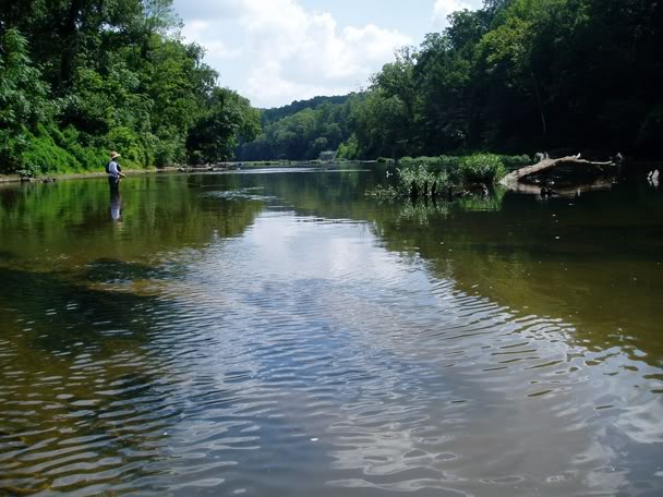 Rapidan River (305 mi.), one of America’s best trout fishing streams, is the largest tributary of the Rappahannock River in north-central Virginia.
 CULPEPER (293 mi.) is a town of 9,600 that has grown rapidly as the expanding Washington suburbs have turned it into a distant “bedroom community.” During the Civil War, it was an important crossroads for a number of armies marching through central Virginia, both Union and Confederate. In the heart of downtown stands the childhood home of Confederate General A.P. Hill, commander of “Hill’s Light Division” under Stonewall Jackson. During the Revolutionary War, the Culpeper Minutemen militia was formed here.
  MANASSAS (258 mi.) began life as Manassas Junction, a strategic railroad crossing that was the focal point of the two Civil War Battles of Bull Run. It is today a suburb of Washington, and is served by the commuter railroad Virginia Railway Express at the Manassas station.
 ALEXANDRIA (234 mi.) and its historic center, Old Town, is a mostly high-income suburb of Washington, populated by many professionals working in federal civil service, the military, or for one of the private companies contracting to provide service to the federal government. Established in 1695, it was ceded in 1791 to the U.S. Government to form the District of Columbia, and retro ceded back to Virginia in 1846 when the District of Columbia was reduced in size to exclude that portion south of the Potomac River. Market Square in Old Town is the oldest continuously operating marketplace in the U.S.
  Potomac River Approaching the Virginia Shore, the Pentagon is visible on the right across Interstate 395 that uses the adjacent bridges. Known as “The Nation’s River,” the Potomac is 383 miles long and forms a part of the borders between Maryland, Washington, DC, Virginia and West Virginia. It empties into the Chesapeake Bay about 100 miles south of here at Port Lookout, Maryland. As we enter Virginia we’ll pass Crystal City, an office, residential and shopping complex on the right.
District of Columbia/Virginia Border (229 mi.)
The railroad bridge across the Potomac River is called the Long Bridge. As we reach the end of the bridge, we enter Virginia.
 WASHINGTON, DC (226 mi.) The nation’s capital, founded in 1790, is a city of grand marble buildings, monuments, parks, prestigious universities, and home to one of the most well known railroad stations in the country. Washington Union Station, designed by architect Daniel Burnham and opened in 1907, had fallen into disrepair until its redevelopment and reopening in 1988. It is now a top tourist attraction housing shops, restaurants, the Washington Metro subway, commuter trains and Amtrak. Out the station’s front door one looks straight ahead to what may be the most powerful building in the world--the U.S. Capitol. But the Federal City is more than just government. Washington houses 172 foreign embassies, and is the headquarters of the World Bank, International Monetary Fund, Organization of American States, Inter-American Development Bank, Pan American Health Organization, numerous trade unions, lobbying groups and professional associations. It is home to a wide range of museums from the various Smithsonian museums such as Air and Space and American History, to the National Archives, the popular Newseum, to the more eclectic International Spy Museum. Washington is home to Georgetown, American, George Washington and Catholic Universities. Washington is one of only 13 cities with teams representing all four major professional sports- -baseball’s Nationals, hockey’s Capitals, basketball’s Wizards and Mystics, and football’s Redskins.
At Union Station our diesel locomotive is replaced by diesel engines and we depart through a tunnel under the Capitol. Once we emerge we get views on the right of the National Air and Space Museum, the Bureau of Engraving and Printing, where all currency and postage stamps are produced, the Washington Monument and the Jefferson Memorial – modeled after the third president’s home at Monticello. The Jefferson Memorial sits next to the Tidal Basin which is ringed by Japanese cherry trees that bring tourists from all over the world when they bloom in late March or early April.
 New Carrollton (217 mi.) is a suburban stop for Amtrak’s Northeast Corridor service, situated alongside the eastern terminus of the Washington Metrorail’s Orange Line. Lying just inside the famous Washington Capital Beltway, it is named for Charles Carroll, a delegate to the Continental Congress and signer of the Declaration of Independence.
 BALTIMORE (185 mi.) is a major seaport founded in 1706 and the largest city in Maryland. It is named after Lord Baltimore, founding proprietor of the Maryland Colony. The Inner Harbor is a successful example of the city’s ambitious renewal effort. Francis Scott Key, a Maryland lawyer, wrote the Star-Spangled Banner here, a recounting of the British attack on the harbor during the War of 1812. Baltimore exhibits examples of architecture from periods ranging over two centuries. Oriole Park at Camden Yards was the first “retro” style baseball park in the major leagues and the inspiration for a generation of baseball venues which have followed. Baltimore is one of Amtrak’s eight busiest stations. The city was home to author Tom Clancy and Olympian Michael Phelps.
 Aberdeen (155 mi.) is home to the U.S. Army’s Aberdeen Proving Ground, established by Congress in 1918. Baltimore Orioles legend Cal Ripken, Jr. hails from Aberdeen.
 Susquehanna River (150 mi.) is the longest river on the East Coast and provides half of the freshwater inflow for the Chesapeake. Geologically, it is regarded as extremely ancient. In 1979, it was the scene of the Three Mile Island nuclear power accident upriver near Harrisburg, Pennsylvania.
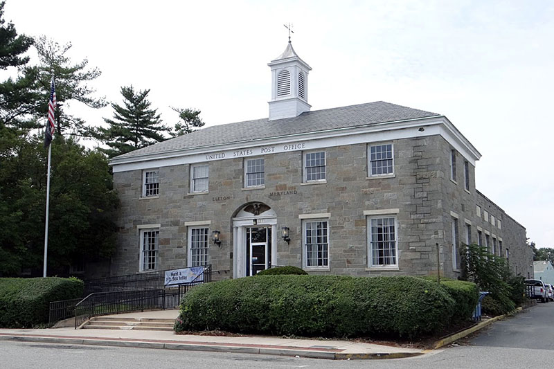 Elkton (138 mi.) marks the head of navigation on the Elk River, which flows into nearby Chesapeake Bay. The town was once famous as a place for eloping couples to marry with a minimum of bureaucracy.
Delaware/Maryland State Line (131 mi.)
 Newark (128 mi.) (pronounced NU-ARK) was founded in 1694. During the Revolutionary War, legend has it that the Stars and Stripes were first flown at the Battle of Cooch’s Bridge outside of Newark. Today, it is home to the University of Delaware. Its central area is compact, walkable and lively, due in large part to university students. Edgar Allan Poe is said to have written parts of “The Raven” while staying at an inn on Main Street.
  WILMINGTON (116 mi.) experienced high growth in jobs and office construction in the 1980s after passage of laws liberalizing bank governance within the state. Many international banks have operations in the city, especially credit card operations. The historic train station was built in 1908. Frawley Stadium, home of the Class A Carolina League Wilmington Blue Rocks baseball team, is on the left shortly after departing.
 The Delaware Memorial Bridge (112 mi.) is visible downriver on the left and connects Delaware with New Jersey. Its eight lanes span the world’s longest twin suspension bridge.
Pennsylvania/Delaware State Line (108 mi.)
 Commodore Barry Bridge (105 mi.) on the right, spans the Delaware River between Bridgeport, New Jersey, and Chester, Pennsylvania. At 1,644 ft., it is the fourth longest cantilever bridge in the world.
 University of Pennsylvania (92 mi.) is visible on the right behind the school stadium, Franklin Field. A member of the Ivy League, it serves 20,000 students with 4,500 professors as one of the most selective universities in the U.S. It offered the nation’s first modern liberal arts curriculum after a board of trustees was assembled by Benjamin Franklin in 1749.
 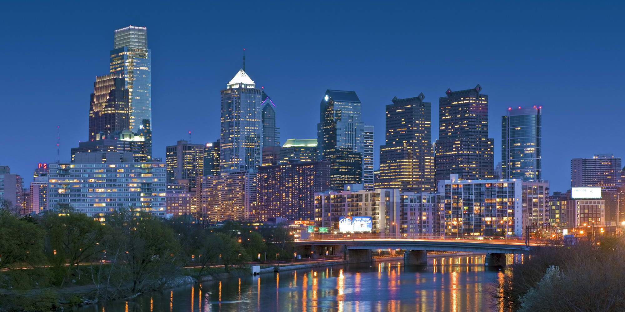 PHILADELPHIA (91 mi.) Before we enter 30th Street Station, Center City can be seen on the left. City Hall Tower holds a statue of William Penn, founder of Pennsylvania, planner and developer of Philadelphia – the “City of Brotherly Love” -- and a devout pacifist and Quaker. Home of the Liberty Bell, the signing of the Declaration of Independence and the U.S. Constitution, Philadelphia was the social and geographical center of the original 13 American colonies, giving birth to the American Revolution. It also served as the nation’s second capital in 1774. Today, its metropolitan area is the fourth largest in the U.S.
No comments:
Post a Comment