The following guide has been copied from the Amtrak route guide available online. The entries have been reversed to represent the direction of travel. Times shown in green are the time my AmeriQuest 2016 schedule says I should be at the indicated station.) Highlighted text indicates links to Wikipedia entries offering additional information for the entry.
Welcome aboard the Southwest Chief,® an unsurpassed route offering the awesome natural wonders of the Grand Canyon, Santa Fe Trail, Raton Pass, Sangre de Cristo Mountains, Sedona Red Cliffs and the Continental Divide –tracing most of the original route of the former Super Chief® between America’s heartland and the west coast. On board, you will experience the comfort and relaxation of train travel while witnessing some of the very best American cultural and geographic icons. We are happy to have you aboard today and want to ensure your trip is everything you want it to be. If there is anything that can be done to make your trip more enjoyable, please do not hesitate to ask any Amtrak employee.
Welcome aboard the Southwest Chief,® an unsurpassed route offering the awesome natural wonders of the Grand Canyon, Santa Fe Trail, Raton Pass, Sangre de Cristo Mountains, Sedona Red Cliffs and the Continental Divide –tracing most of the original route of the former Super Chief® between America’s heartland and the west coast. On board, you will experience the comfort and relaxation of train travel while witnessing some of the very best American cultural and geographic icons. We are happy to have you aboard today and want to ensure your trip is everything you want it to be. If there is anything that can be done to make your trip more enjoyable, please do not hesitate to ask any Amtrak employee.
HOST RAILROADS are the freight and commuter railroads that Amtrak contracts with to operate Amtrak passenger trains. The Southwest Chief travels Los Angeles - Chicago - BNSF Railway Company (BNSF).
 CHICAGO (3:00 pm CT - June 13, 2016) Vibrant and energetic, Chicago is the industrial core of the Midwest, and a major transportation hub. In the heart of America’s agriculture belt, it is a leading distributor of farm products. Its many regional food specialties reflect the city’s ethnic and working class roots. Chicago’s spirit is also exemplified in its unique architecture; it is here that the word “skyscraper” originated with the first one built in 1885. The arts and sciences are alive with an abundance of world renowned theaters and museums. The city boasts Wrigley Field, one of baseball’s oldest parks, and the Sears Tower, tallest building in the U.S. The Merchandise Mart is the world’s largest commercial office building and rests on the banks of the Chicago River. The river became an engineering marvel in 1900 when engineers reversed its flow into the Mississippi River drainage. Most Amtrak long-distance trains either originate or terminate in Chicago, connecting to other service.
 NAPERVILLE (3:35 pm CT - June 13, 2016) was founded in 1831 by Joseph Naper. Due to the enormous growth of high-tech companies and its globally renowned public schools, the city is the wealthiest in the U.S. of all cities with a population of 90,000 and over. The Naperville Public Library was ranked number-one in the U.S. for eight years running. The four-mi.-long Riverwalk along the west branch of the DuPage River is known as the “crown jewel” of the city. This is the station for Chicago's western suburbs. RTA commuter trains provide connections to Aurora, LaGrange, Brookfield and other points. This attractive suburb is a high-tech industrial center and is known for its Riverwalk, a restored historic village, and an example of Frank Lloyd Write's architecture.
 Aurora is the second largest city in Illinois. It adopted the nickname “City of Lights” in 1908 after being one of the first cities in the state to adopt all-electric street lighting in 1881. Prominent companies past and present include the Chicago, Burlington and Quincy Railroad (later Burlington Northern) and Caterpillar Incorporated. Author Clive Cussler hails from Aurora. The city was the setting for the 1992 movie Wayne’s World. This was a transfer station for stagecoaches in the 1830's. It was also the birthplace of the Chicago, Burlington and Quincy Railroad in 1849. Transportation has always played a large role in Aurora. A large bulldozer factory can be seen to the right.
Aurora is predominantly in Kane County and DuPage County, with portions extending into Kendall and Will counties. It is located in the outer region of Greater Chicago in the U.S. state of Illinois. It is the second most populous city in the state, and the 114th most populous city in the country. The population was 197,899 at the 2010 census, and was estimated to have increased to 199,963 by July 2013.
Once a mid-sized manufacturing city, Aurora has grown tremendously since the 1960s. Founded within Kane County, Aurora's city limits and population have since expanded into DuPage, Will, and Kendall counties. Between 2000 and 2003, the U.S. Census Bureau ranked Aurora as the 34th fastest growing city in the United States. From 2000 to 2009, the U.S. Census Bureau ranked the city as the 46th fastest growing city with a population of over 100,000.
In 1908, Aurora officially adopted the nickname "City of Lights," because it was one of the first cities in the United States to implement an all-electric street lighting system in 1881. Aurora's historic downtown is located on the Fox River, and centered on Stolp Island. The city is divided into three regions, The West Side, located on the west side of the Fox River, The East Side, located between the eastern bank of the Fox River and the Kane/DuPage County line, and the Far East Side/Fox Valley, which is from the County Line to the city's eastern border with Naperville.
 MENDOTA (4:24 pm CT - June 13, 2016) is home to the Sweet Corn Festival that attracts thousands of visitors to the city each August. It features a parade, carnival, beer garden, free sweet corn and other special events. Its two lakes are used for both boating and fishing. Notable natives include Helen Hokinson, long-time cartoonist for The New Yorker.
 Princeton (4:46 pm CT - June 13, 2016) was settled in the 1830s by families from New England and the Mid-Atlantic states. Its name was, according to legend, drawn from a hat. Its former nickname, “The City of Elms,” is no longer used due to an epidemic that struck the elm trees and killed off almost every single one of them. Its major employers include Ace Hardware Retail Support Center and MTM Recognition, makers of world championship rings. Actor Richard Widmark’s parents owned a hardware store here during his early years. One of the founders of the Republican Party, John Bryant, made his home in Princeton. It was settled by New Englanders in 1833. It is the "Pig Capital of the World." The small red and brown A-frame houses in the fields are what the pigs call home.
 Kewanee is a Native American word for prairie chicken. An industrial town, it was best known as home to the Kewanee Boiler Corporation, manufacturer and seller of steam boilers throughout the world for well over 100 years. It is also the acknowledged Hog Capital of the World, holding an annual Hog Days festival every Labor Day weekend, complete with a parade, flea market and carnival. The small industrial city of Kewanee was settled alongside the Spoon River in 1836 by New Englanders.
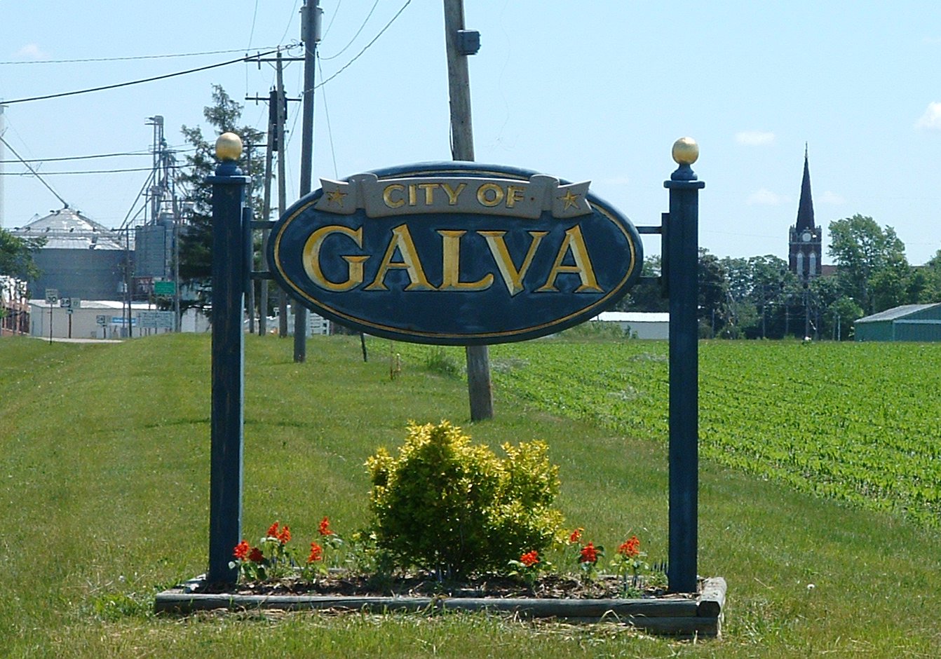 Galva is located in a part of the state that was known as the Central Military Tract, the purpose of which was to give this land to soldiers who had served in the War of 1812. The original land was awarded to Jacob Joy, who owned it only one month before selling it to James Bonham. The name Galva is a revision to the original name of a Swedish seaport from which many of its early settlers had sailed, Gefle. Today, it has an extremely high ratio of green space to residents and hosts an annual 4th of July “Freedomfest” fireworks display and antique car show that attracts thousands from miles around. "Bishop's Hill" was a Swedish utopian society of religious dissidents that settled in Galva until the Civil War. It is now an historic landmark.
 GALESBURG (5:38 pm CT - June 13, 2016) was the home of writer and historian Carl Sandburg and the site of the fifth Lincoln-Douglas debate at Knox College in 1858. It was also home to the first anti-slavery society in Illinois and an important stop on the Underground Railroad during the Civil War. It will soon be home to the new National Railroad Hall of Fame. Galesburg plays host to the Railroad Days festival each June and the Black Earth Film Festival each September. Other notable residents include George Reeves, TV’s Superman, Charles Rudolph Walgreen, founder of the drug store of the same name, and George Washington Gale Ferris, inventor of the Ferris wheel. According to legend, the Marx Brothers received their nicknames here during a poker game in 1914. This town was planned and settled by a fundamentalist group from Oneida, N.Y. Olmsted Ferris developed popcorn to such an art here, he was invited to give a corn-popping demonstration to England's Queen Victoria. The train passes by some of the best farmlands in the country, held in families for generations because it is so fertile. You'll see many thousands of acres of alfalfa, soybeans, corn, and wheat fields. Here, the soil yields 200 bushels of corn per acre. Rolled bales of hay doting the rolling hillsides in haying season each weigh about a ton. You'll also see large modern corn dryers, and occasional steeple-top barns built before bailing came into practice. The open tops provided ventilation to prevent fires. Notice, on the right, Burlington's famous 4-6-4 "Hudson" passenger locomotive used in the 1930s. Galesburg is the home of the Annual Galesburg Railroad Days.
Iowa/Illinois State Line
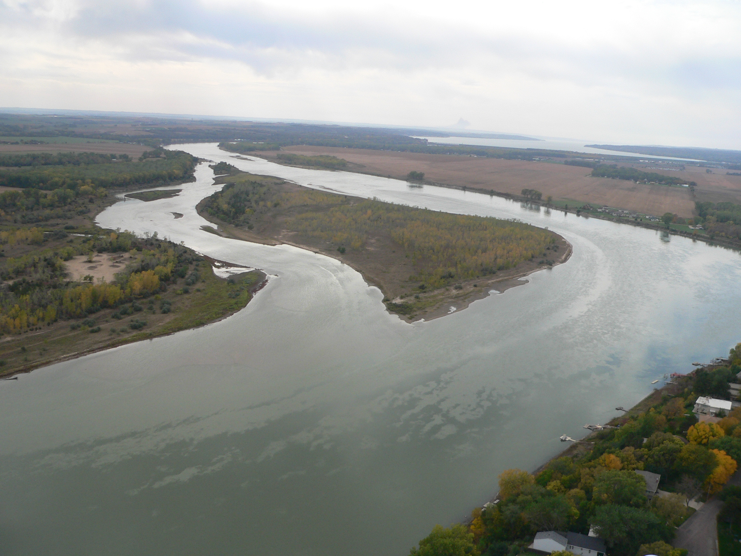
 Mississippi River is the second longest river in the U.S., running from its source at Lake Itasca, Minnesota, to its mouth in the Gulf of Mexico. It runs through 10 states and was used to define the borders between them. Although the river has since shifted, these borders still follow the former bed of their establishment. Cross the state line between Iowa and Illinois over the wide Mississippi River on a 3,347-ft. long steel bridge. It has the world's largest double-track, double-decker swing span. The bridge pivots to allow river traffic to pass.
 FT. MADISON (6:24 pm CT - June 13, 2016) is situated on the Mississippi River and is home to Iowa State Penitentiary, the state’s maximum security prison for men. Here is the last remaining double swing-span bridge on the Mississippi, a top level for cars and a bottom level for trains; it is also the world’s largest such bridge. Completed in 1927, it spans 270 ft. The Southwest Chief travels only 20 miles in Iowa, and this is its only stop. The city was named for Fort Madison, built in 1808-9 to protect settlers from Indian raids and named for President Madison. The fort was attacked many times during the War of 1812, and finally burned by its own soldiers in 1813 to divert warring Indians. The settlers made their escape through a tunnel and then fled on a boat down the river. The One Chimney Monument on the right commemorates the fort. The city is also site of the annual Tri-State Rodeo. The Schaefer Eton plant is on the right, east of the station.
Nauvoo (10 Min./60 Min.) Across the river to the left, this city was an important Mormon settlement, until the Mormons -- following a vision of their leader -- suddenly crossed the ice and left in 1846. Their leader, Joseph Smith, was killed at the hands of a mob at the jail in nearby Carthage. Today, the town is being restored as a Mormon Memorial. Here are Concord grape vines planted by the French 100 years ago, still bearing fruit.
 Des Moines River is a tributary of the Mississippi approximately 525 mi. long. The origin of its name is thought to be French, meaning “river of the monks,” who built huts near its mouth. The river has a long history of flooding, especially in 1944, 1993 and 2008. This is the state line between Missouri and Iowa. The train now approaches the great Missouri River.
Missouri/Iowa State Line
 Missouri River begins in southern Montana in the Rocky Mountains and ends at the Mississippi just north of St. Louis. At 2,500 mi., it is the longest in the U.S. The river meanders from bluff to bluff in the flat Midwest, leading to the nickname “Wide Missouri.” It is also known as “Big Muddy” due to its high silt content. Cross a 135-ft. high steel bridge. On the right, note remains of Fort Osage, built in 1808 during the Osage Indian War.
Marcelene Walt Disney spent part of his childhood here. The initials he carved into a school desk are still legible, as are the hand-cut charcoal drawings on the northwest wall of the home he lived in until age six. A born doodler, Disney showed great talent even as a child. His star "doodle," Mickey Mouse, who turned 60 in 1989, was in fact created while Disney traveled the route of the Southwest Chief on the Santa Fe Railway. Wal Disney Park is on your right, sporting steam engine #2435 of the old Santa Fe. Just east of town, note the Jonathan apple orchards on the left.
Mendon (11 Min./89 Min.) On the right is the Swan Lake National Game Reserve. 11,000 acres filled with ducks and geese that migrate to Canada. This area is so rich in water fowl, duck blinds lease from $200 - $2,000 a year. Missouri hunters harvest more than 50,000 geese and 200,000 ducks a year.
Bosworth (21 Min./79 Min.) Cross the Grand River, flanked by pecan trees.
 Sugar Creek was originally known as Wayne’s Landing, an important link in the westward expansion that served as a port to receive supplies for early pioneers. The city of Sugar Creek was founded in 1920. For some 40 years, the area was home to a first-class pleasure resort serving nearby Kansas City residents. This was once the headquarters of Jesse James, killed in nearby St. Joseph.
 KANSAS CITY (11:10 pm CT - June 13, 2016) is situated at the junction of the Missouri and Kansas Rivers, Kaw Point. Nicknamed the “Heart of America,” the location was good for building settlements, owing to the central crossroads at the confluence of the rivers. Once opened to Euro-American settlement, the area became the first battlefield in the conflict over slavery and southern secession that led to the Civil War. Today, the city is home to a General Motors plant that manufactures the Chevrolet Malibu and Saturn® Aura. Originally called Westport Landing, this was the starting point for the old Santa Fe Trail, the town where westerners like Bat Masterson and Wild Bill Hickock would buy last-minute provisions before heading west. In 1933, Union Station saw some wild action of its own. Attempting to help underworld figure Frank Nash while he was being moved from Little Rock to Leavenworth Prison, attackers killed an FBI man, two city detectives, a police chief, and Nash himself in what became known as "The Union Station Massacre". Today, together with its sister city in Kansas, the city is a marketing and transportation center. It is the gateway to the Southwest, with more than 300 parks and perhaps more fountains than any city outside Europe. Kansas City has several well-known shopping complexes, including Crown Center, just east of the station on the left.
 Cross the state line from Kansas City,Missouri, into Kansas City, Kansas .
 LAWRENCE (11:52 pm CT, June 13, 2016) was founded in 1854 and named after Amos Adams Lawrence, a prominent politician and antislavery partisan. James Naismith, the inventor of the game of basketball, founded the basketball program at the University of Kansas here. The culture of Lawrence is political activism, the arts and the University of Kansas athletic teams. Its North vs. South Music Festival has become a staple of the music scene.
 TOPEKA (12:29 am CT, June 14, 2016) was laid out in 1854 as a Free-State town after passage of the Kansas-Nebraska Act, which allowed settlers to vote on the issue of slavery. After it was named capital in 1861, it took 37 years to build the capitol building using Kansas limestone. The city was also home to Linda Brown, named plaintiff in the landmark school integration case Brown v. Board of Education. Notable natives include actress Annette Bening and broadcaster Bill Kurtis, who got his start reporting at a local affiliate in Topeka.
 NEWTON (2:45 am CT, June 14, 2016) was known as the wickedest city in the west as a result of the famous 1871 Gunfight at Hide Park, which left eight men dead. The next year, the western terminal for the Santa Fe Railway and Chisholm Trail were established here. Today, the city is included as part of the Wichita metro area and lies at the “bull’s eye” of North America.
 HUTCHINSON (3:20 am CT, June 14, 2016) hosts the Kansas State Fair and is home to the Space Center aerospace museum. Salt was discovered here in 1887, and three companies now operate mines and plants locally. Excavated portions of one mine are used for archival storage of movie and television masters, including The Wizard of Oz, Gone with the Wind and Star Wars, among others. The world’s longest grain elevator was built in Hutchinson in 1961.
 DODGE CITY (5:25 am CT, June 14, 2016) is well known to generations of Americans as the stage of action for the radio and TV western drama, Gunsmoke. There was good reason for this, as by 1876 Dodge City had become the virtual queen of cow towns. Some of the more infamous to dwell in its environs included Wyatt Earp, Doc Holliday and Bat Masterson. Today, Dodge City is a meat packing capital, with close to 1,200 cattle processed per day. This most famous of western cities was first a trading post, then a Civil War fort (Fort Dodge), then a railroad boom town. The railroad turned the city into a major shipping point for all buffalo by-products, and later for longhorn steer herded up on dusty cattle drives from Texas. Here, lawmen and good guys including Bat Masterson, Wyatt Earp, Col. George Custer, Doc Holliday, and vaudevillian Eddie Foy lived -- and notorious bad guys died, many sent to Boot Hill, on your left. Hangman's Tree still stands, and Front Street, on the right, has been restored to look as it did in 1875 when the town was known as "the wickedest little city in America." At the station itself are two sundials marking the nearby time zone crossing.
 GARDEN CITY (6:21 am CT, June 14, 2016) is the county seat of Finney County. It is the site of the Garden City Community College, home to the Lee Richardson Zoo, and one of the towns depicted in Truman Capote’s In Cold Blood. Former Colorado Governor Roy Romer hails from Garden City. This town, named by a passing hobo for the beautiful garden of its founder's wife (Mrs. William D. Fulton), also claims the world's largest free public swimming pool and the largest buffalo herd. Garden City is a center for agribusiness, oil and gas fields, and beef processing.
Colorado/Kansas State Line
Coolidge (50 Min./25 Min.) Cross the state line between Kansas and Colorado, and you change time zones. If you are traveling eastward, set your watch forward one hour; if you are traveling westward, set your watch back one hour.
 LAMAR (6:59 am MT, June 14, 2016) is a county seat and the planned northern site of the Pierre Auger Observatory of ultra-high energy cosmic rays. The other international site is in western Argentina. High-profile natives of Lamar include Floyd D. Hall, a past president of the now-defunct Eastern Airlines. This is the "Goose Hunting Capital of the Nation." At the west end of the station on your left, note the Madonna of the Trails statue, one of many erected by the Daughters of the American Revolution to commemorate the "National Old Train."
 Las Animas sits along the Arkansas River just west of where the Purgatory River flows into the Arkansas. It is home to the Kit Carson Museum and the site of Santa Fe Trail Day, a celebration of pioneers who took the trail west, on the last weekend in April. Notable natives include Ken Curtis, the actor who portrayed “Festus” on TV’s Gunsmoke, and frontiersman Kit Carson. This town takes its name from the Rio de las Animas Perdidas (river of lost souls), named for a wagon train of settlers that camped one night by the river now known as the Purgatoire. According to legend, they disappeared by morning, victims of an Indian attack. Further east, on the left, is John Martin Reservoir. The dam, built by the Army Corps of Engineers, is 2.64 miles long.
 LA JUNTA (8:15 am MT, June 14, 2016) houses two well-known museums: Bent’s Fort, an important trading post in the old west, and the Koshare Indian Museum, regarded as one of the finest collections of Native American artifacts in the world. The latter hosts a unique Boy Scout/Explorer program that trains Scouts in both Indian dance and costumes. The city has a major rail yard for the Burlington Northern Santa Fe Railway to assemble trains and add locomotives for the climb across Raton Pass. Writer Ken Kesey, author of One Flew over the Cuckoo’s Nest, was born in La Junta.
Sunflower Valley (55 Min./29 Min.) Alfalfa, corn, sugar beets, and wheat grow here. Further east, the train crosses the Comanche National Grassland.
 TRINIDAD (9:50 am MT, June 14, 2016) for many years housed coal miners who worked the Raton Basin. Its location at the foot of Raton Pass has made it a favored route for travelers by foot, horse, ox-drawn wagon and railroad. Famous residents include famed old west gunman Bat Masterson, who once served as town marshal. The town's name, meaning "trinity," is displayed atop 400-ft. high Simpson's Rest on the right, named for an old pioneer buried there. Known for its coal, Trinidad is also remembered for a battle fought here between Spanish settlers and U.S. settlers on Christmas Day, 1867. Just behind the city is Fisher's Peak on the left, a rocky promontory rising almost 10,000 feet. Back and to the right east of Trinidad are the twin Spanish Peaks (called "Breasts of Mother Earth" by the Indians), and lovely views of the snow-capped Sangre de Cristo Mountains.
New Mexico/Colorado State Line
 Purgatoire River was named, according to legend, during the time when Spanish Conquistadors were exploring it in search of the Seven Cities of Gold in 1594. Finding gold, they had Native American slaves dig it for them, then killed their slaves and headed out with their illgotten gold. They were subsequently ambushed and wiped out to a man, and so were thought to be in Purgatory.
Morley (21 Min./51 Min.) On the hill to your right are the ruins of an old Spanish mission and the old Morley coal mine.
 Wootton Ranch was built by “Uncle Dick” Wootton, a frontiersman, trapper, buffalo hunter, Indian fighter, guide, teacher, rancher, farmer and operator of a toll road. The first meeting to consider Colorado statehood was held in the second story of his store. Turning down an offer from the Santa Fe Railroad to buy his road in 1878, he instead asked for free groceries and rail passage for his wife for life. The railroad agreed.
 Raton Pass is a federally designated National Historic Landmark. Located on the eastern side of the Sangre de Cristo Mountains between Trinidad, Colorado and Raton, New Mexico, it furnishes the most direct land route between the Arkansas River valley and the Cimarron River Valley. It was later developed into a road and then a railroad route. Here the train ascends 175 feet per mile to the highest point along the route-7,588 feet on the west end of a half-mile tunnel.
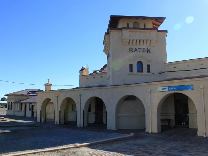 RATON (10:56 am MT, June 14, 2016) was founded in 1880 at the site of Willow Springs, a stop n the Santa Fe Trail. It quickly developed as a railroad, mining and ranching center for northeast New Mexico. The Fireballs, who had a number-one hit in 1963 with Sugar Shack, hail from Raton. A railroad and coal mining center, Raton is at the base of the Raton Pass which crosses the Sangre de Cristo Mountains. Raton is also the gateway to Philmont Boy Scout Ranch, a 137,441 acre national center of the Boy Scouts of America.
 Clifton House Ruins On your left, you can see the remains of this layover point on the old Santa Fe Trail. Built by rancher Tom Stockton in 1867, it was also known as Red River Station and Red River Hotel. This stagecoach stop was famous for its food and lodging and was a highlight for travelers on the Mountain Route of the Santa Fe Trail.
Maxwell (21 Min./83 Min.) Lucien B. Maxwell, hunter and trapper, married into the largest land grant ever awarded in the Western Hemisphere, stretching 1.75 million acres from Shoemaker to Starkville. He named the seat of his famous empire Cimarron, Spanish for "wild." His freind Kit Carson came to live nearby. Today, the area is the Maxwell Land Grant Wildlife Refuge.
Springer (36 Min./68 Min.) Cross the Cimarron River after following the Canadian River. Chances are, just west of Springer, you'll see antelope on your left. On the right in the distance is 12,441-ft. Baldy Peak.
 Wagon Mound On your left, the butte that looks like a prairie schooner led by horses served as a major landmark along the Santa Fe Trail. It is now a National Historic Landmark.
 Shoemaker Canyon was named for Captain W. R. Shoemaker, a Civil War ordnance officer at Ft. Union near Las Vegas. He was esteemed and respected by the civilian population and the military alike. Today, a ranching and farming community of the same name occupies nearby land some three mi. south of U.S. 85. The train follows and crosses the Mora River through this area that was once a major trade route between plains and Texas Indians.
 Watrous played an important commercial role in New Mexico’s early history, encompassing its many cultures. It was the site of Indian encampments, a Santa Fe Trail resting spot, a railroad stop and a highway stop. It was named for Samuel B. Watrous, who made his way from Vermont to New Mexico in 1835. He eventually became a selfcontained economic boom, building a 20-room hacienda, and catering to the gold seekers and settlers who stopped to trade at his store on the Santa Fe Trail. On your leftare the ruins of a Fort Union outpost. Ft. Union, built in 1851 to guard the Santa Fe Trail and Cimarron Cut-off, was a supply fort -- one of the biggest in the Southwest. The Cut-off was an alternative route to La Junta, avoiding Raton Pass. It was easier to cross but more vulnerable to Indian raids.
 LAS VEGAS (NM) (12:38 pm MT, June 14, 2016) was established in 1835, laid out in a traditional Spanish Colonial style, and soon prospered as a stop on the Santa Fe Trail. During the railroad era, it boomed. By the turn of the century, it was a thoroughly modern city, one of the largest in the southwest. One of the few remaining Harvey House hotels, the Castenada, can be seen on our left. Among the notorious people who came with the railroad were Doc Holliday, Jesse James, Billy the Kid and Wyatt Earp. Today, the city is home to the Carnegie Library, Rough Rider Memorial and a large number of historic structures. 10,000 years before Coronado discovered this area in 1541 and the Spanish named it the "meadows," Indians occupied its lands. In 1833, white settlers formed a town on the west bank of the river. But, when the railroad arrived, a rowdier New Town developed on the east bank, attracting unsavory folks like Billy the Kid, until West Bank vigilantes cleaned it up and cleared it out. That large building adjacent to the station was La Castenada, one of many Harvey House restaurants and hotels built along the Santa Fe route. The Harvey House waitresses were immortalizd in the Judy Garland movie, The Harvey Girls. This Harvey House has another claim to fame. In 1899, Teddy Roosevelt joined his Rough Riders here for a reunion. Las Vegas honors the event with a Routh Riders museum.
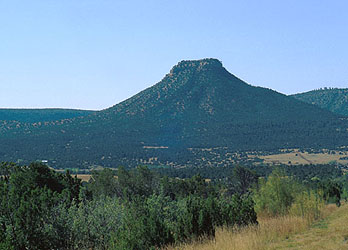 Bernal (22 Min./84 Min.) On the right are ruins of the first stagecoach relay station on the old Las Vegas - Santa Fe stage line. Note Martinez Canyon on the left, between Bernal and Las Vegas.Starvation Peak (25 Min./70 Min.) In the early 19th-century, the distinctive flat-topped, rock-capped mesa on the left became the last stand of 30 Spanish settlers who, according to legend, fought off attacking Navajos with rocks, but starved to death when the Indians surrounded the peak.
S-curve (30 Min./67 Min.) We now start a huge double S-curve, during which you can see both ends of the train as it winds sharply to gain altitude while crossing the mountains.
 Pecos River is 926 mi. long and empties into the Rio Grande River near Del Rio, Texas. The river played a large role in the exploration of Texas by the Spaniards. During the latter half of the 19th century, “West of the Pecos” was used as shorthand to reference the rugged frontiers of the Wild West. The old Spanish mission of San Miguel, built in 1775, is on your left.
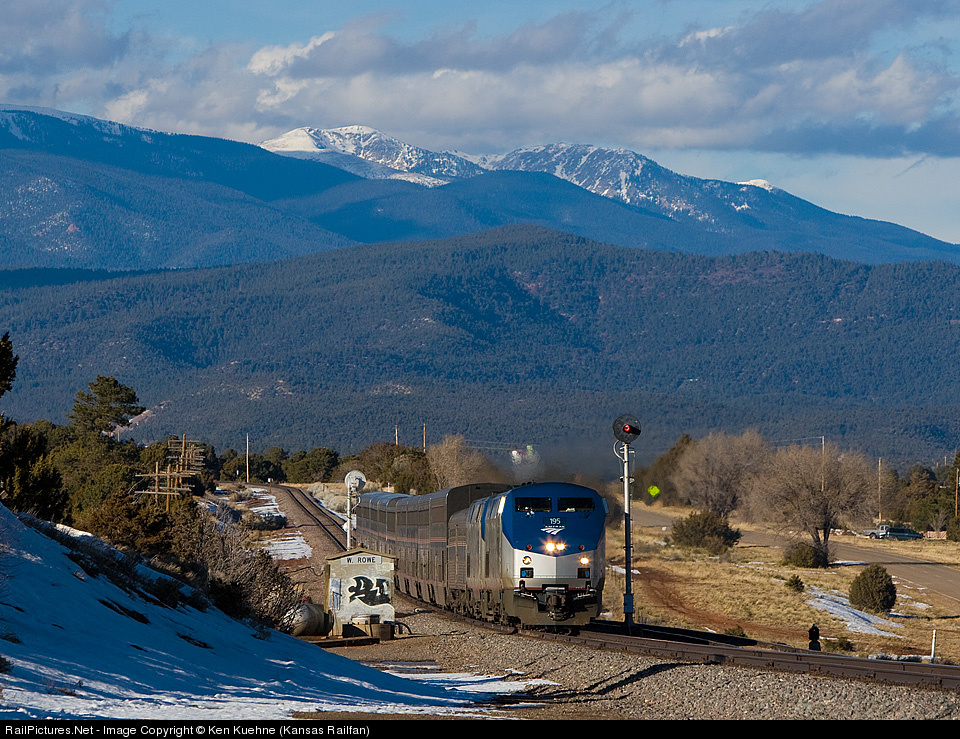
 Santa Fe National Forest is a protected forest established on July 1, 1915 by the U.S. Forest Service. It covers 1,567,181 acres, ranges in elevation from 5,300 ft. to 1,103 ft., and is divided into five ranger districts. This immense forest is known for its trout fishing, hunting, and prehistoric Indian ruins. The train follows the Glorieta Mesa on the left.
Glorieta (79 Min./26 Min.) On your right, you can see the Glorieta Baptist Assembly, a huge retreat center. During the Civil War, Glorieta was the site of an unusually westward battle between Colorado and Texas volunteers. Texas Confederates won, but ultimately had to retreat because Union cavalry, during the fight, had secretly crossed the treacherous Sangre de Cristo peaks at Canoncito to meet and burn a Confederate supply train. Without supplies, the Texans were helpless.
 Cañoncito is a Navajo Nation reservation now known as Tohajiilee, its 121,000 sq. mi. containing approximately 1,649 persons. From Glorieta to Lamy, you descend 1,000 feet in 10 miles through areas of bright red, dry, creek beds. Called the Glorieta Pass, this portion of our route cuts through dry, rock-strewn hills dotted with juniper, Ponderosa Pine, scrub oak, pink tamarisk, and turquoise blooming sage (chamisa). On your right is the first look at the Sangre de Cristo Mountains, meaning "blood of Christ" and commemorating the suffering of the early Spanish explorers who crossed them.
 Apache Canyon and Glorietta Pass are the sites of an 1862 Civil War battle called “the Gettysburg of the West” for its importance in nullifying the Confederates’ push into the Southwest and forcing their retreat from the New Mexico territory, ending dreams of occupation and a Southwestern stronghold for the Confederacy. The train weaves through a spectacular granite gorge here, so narrow the rock is at times just one foot from the train. This is considered the oldest strata of the Rockies.
 LAMY (2:24 pm MT, June 14, 2016) was originally a railroad town. Once builders realized the hills surrounding Santa Fe were impractical for the mainline, Santa Fe residents subsidized a branch line. Today, a short line railroad connects the two towns with freight and tourist service on that spur. While home to only 137 people, the town is nonetheless a significant railroad junction. In the 19th-century, Archbishop Jean Baptiste Lamy received a grant for this town from the Spanish and served as a missionary for almost 40 years. The central character of Willa Cather's Death Comes for the Archbishop was based upon Lamy, and the ruins of his first school are on the left as you enter town. Note the Legal Tender Saloon to your right, containing $250,000 in art and antiques. Today, the town is known as the stop for Santa Fe. Shuttle service between the adobe-style station and Santa Fe makes connections easy.
Although the Santa Fe Railway was originally named for Santa Fe, its main line never went there. The terrain was too difficult to lay the necessary tracks. The capital of New Mexico, Santa Fe has been the capital of one region or another since its foundation in 1610 as La Villa Real de la Santa Fe de San Francisco de Assisi. It is the oldest city in the Southwest and was the end of the line for the old Santa Fe Trail. Today, Santa Fe is known as a cultural haven, home of the Santa Fe Opera and the Santa Fe Chamber Music Festival, and as a residence of prominent artists. In fact, Santa Fe is said to rank third worldwide in art sales, behind New York and Paris. The city is also the gateway to Taos and other northern New Mexico year-round recreation areas.
 Los Cerrillos is home to the Museum of Northern New Mexican History, the Rock Shop and the Petting Zoo. Contained in the museum are cardboard cutouts of the characters in the 1988 film Young Guns, a fictionalized retelling of the adventures of Billy the Kid during the famous Lincoln County War in New Mexico during 1877-1878, starring Emilio Estevez, which was shot on location in Los Cerrillos. This area is so rich in concentrated minerals, that in one mine were found two kinds of coal, lead, silver, turquoise, and gold. Thomas Edison tried but failed to extract gold from the river sand you see here.
 Ortiz Mountains feature an educational preserve that is a treasure for naturalists and adventure seekers. The first gold mines west of the Mississippi were dug here in 1821, and the “Old Ortiz Lode” became the location of the first major gold rush in the U.S. Look in the distance to your left, and you can see these mountains, site of one of the country's first gold mines, opened in 1830. The whitish tailings from the mines are still visible. Scenes from the movie Superman featuring Amtrak® were shot along this stretch of rail line.
Santo Domingo Pueblo (35 Min./42 Min.) On the Rio Grande, this 1598 town on your right has excellent examples of traditional beehive-shaped "hornos", still in use.
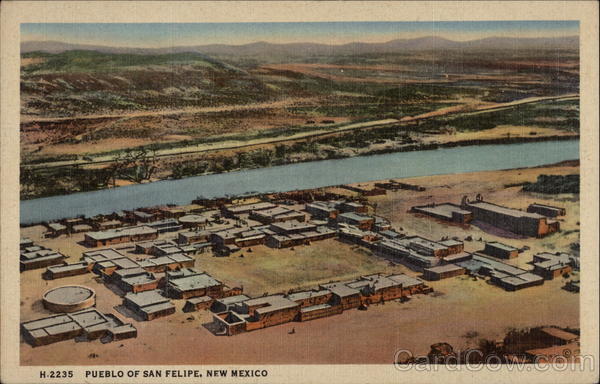 San Felipe Pueblo, founded in 1706, comprises some 2,000 Native Americans who speak an eastern dialect of the Keresan language. It celebrates the annual Feast of St. Philip on May 1, when hundreds participate in traditional corn dances. The tribe also operates Casino Hollywood and Hollywood Hills Speedway.
Located at the foot of the Black Mesa, this pueblo is in the San Felipe Indian Reservation and was established 500-600 years ago. Note the "Kiva" (religious council chamber) beside the Catholic church, on the right.
 Sandia Pueblo is a Native American tribe inhabiting a 39-sq.-mi. reservation between Albuquerque and the foothills of the Sandia Mountains. It has a tribal government that operates the Sandia Casino, the Bien Mur Indian Market Center and Sandia Lakes Recreation Area. In addition to seeing a lovely church on your left, you can also get the best view form here of the 10,678-ft. high Sandia Crest, surrounded by Cibola National Forest.
 Sandia Mountains immediately to the northeast of Albuquerque are thought to be named for the watermelon (Sandia in Spanish) because of their reddish color at sunset coupled with a thin zone of green conifers (the “rind”) near the top. In addition to a tramway, one may access the mountain by New Mexico 536, a road from the east to the bottom of the ski area, with a scenic overlook, communications center, gift shop and restaurant.
  ALBUQUERQUE (3:50 pm MT, June 14, 2016) is the largest city in New Mexico and is the central crossroads of the state. It is home to the University of New Mexico, Kirtland Air Force Base and the Sandia National Laboratories. Founded in 1706 as a Spanish colonial outpost, by 1900 it had become a tidy town boasting an electric street railway. The establishment of the Sandia Base would make the city a key player in the Atomic Age, and its dry climate brought many to the city in search of better health. It has one of the highest elevations of any major city, and hosts the largest hot air balloon gathering in the world. The Sandia Peak Tramway is the world’s longest such device, scaling the Sandia Mountains, and providing access to hiking and biking trails, skiing and other activities. A long list of notable natives includes race car driver Al Unser, actor and comedian Bill Daily, footballer Ronnie Lott and world champion boxer Johnny Tapia. This modern city, known for its successes in nuclear research and business, dates back to 1706 when it was founded and named for the Duke of Albuquerque, the Spanish viceroy who once ruled the surrounding area known as "New Spain." Albuquerque celebrates its past in the restored Old Town, and celebrates its present with the renowned October Hot Air Balloon Festival, when the sky almost bursts with colorful balloons. Albuquerque is a service stop for the Southwest Chief. Here, passengers have time to stretch their legs or buy silver and turquoise jewelry, crafts, and souvenirs sold on the station platform by Tiwa Indians from Isleta.
 Rio Grande River is the third longest river system in the U.S. and, further south, serves as the natural boundary between the U.S. and Mexico. Despite the name and its length, it is not navigable. The name means “big river” in Spanish. Eventually flowing into the Gulf of Mexico, the Rio Grande crosses the path of the Southwest Chief here. Note the tamarisk trees (also called salt cedars), and lavender-topped bushes that require little water. On your right is a feed lot filled with cattle.
Isleta Indian Reservation (13 Min./120 Min.) On your left, the St. Augustine church, established in 1613, is still in use. Here adobe-style homes of generations ago mix with new houses in the same style, most with "hornos" in their yards.
 Kneeling Nun is a large columnar rock monolith that resembles a praying nun. Legend has it that she shared a forbidden love with a handsome soldier and was turned to stone for abandoning her vows. The monolith overlooks the Santa Rita open-pit copper mine.
 Note the gypsum cliffs on your right and tailings from uranium mines.
Laguna Indian Reservation (60 Min./73 Min.) Pueblos visible in this area are Paraje, Laguna (the youngest and second largest of the pueblos), and Mesita pueblo on your left.
Acomita (68 Min./67 Min.) On your left, this pueblo is noted for its adobe-style church. Hundreds of Acoma Indians live in this agricultural area. Thirteen miles south is the "Sky City" of the Acomas, a pueblo built atop a 365-foot mesa and used continuously for 850 years.
McCartys (72 Min./63 Min.) On your leftis the first of many Indian pueblos visible along this route, this one a part of the Acoma Indian Reservation. On a bluff above the tracks on your leftis a 200-year-old mission church. Throughout the pueblo are squat stone homes, many of which are hundreds of years old, with traditional beehive-shaped "hornos" -- ovens used for baking bread -- out in front.
Anzac (76 Min./59 Min.) Note the exposed lava beds on your left. These "rocks" are a haven for rattlesnakes because the black lava stays warm throughout the day and night.
Bluewater (94 Min./42 Min.) Mount Taylor, rising 11,301 feet. is visible to your right. Named for President Zachary Taylor, the mountain is an extinct volcano that is responsible for the many lava beds throughout the region.
 Grants was founded as a railroad town and prospered as a result of nearby logging operations. After the decline of logging, it gained fame as a “carrot capital” of the U.S. The discovery of uranium ore nearby sparked a mining boom that lasted until the 1980s.
 Continental Divide is a line of elevated terrain which forms a border between two watersheds, separating those of the Pacific from those of the Atlantic or Arctic Oceans, running from Alaska to the tip of South America.
 Ft. Wingate Army Depot is part of the Eastern Navajo Agency of the Navajo Nation. Ft. Wingate held a contingent of federal soldiers in the 1880s that kept the peace on the frontier. From 1918 until its closure in 1993, the installation stored and demolished ammunition. The facility is occasionally used to shoot missiles to the White Sands Missile Range, some 150 mi. to the south. A technology company uses space here to demilitarize a variety of surplus munitions by breaking them down in to recyclables.
Pyramid Rock (128 Min./8 Min.) Behind this aptly-named landmark and on your right is Church Rock, a spire-topped rock where Indians say a jilted Indian maiden jumped to her death. Also in the Red Rocks are pre-pueblo Anasazi settlements, once centers of a prehistoric Indian trading network.
 Red Rock State Park is the site of the huge campground that houses participants in the Inter-Tribal Ceremonial. Each year, more than 50 tribes gather in the red sandstone and limestone cliffs on your right for the Inter-Tribal Indian Ceremonial, an all-Indian rodeo and dance competition.
Red Cliffs of New Mexico For the next hour east of Gallup, the train follows these famous hills, noted for their changing colors in the bright desert sun. Legend has it that the rocks, once gray, got their red color from the blood of a wounded great stag as it fled through the hills. Some of the hills are as high as 7,248 feet. All are spectacular.
 GALLUP (7:08 am MT, June 14, 2016) was founded in 1891 as a railhead for the Atlantic and Pacific Railroad. It is situated in the heart of Native American lands. Its historic El Rancho Hotel has hosted a large array of famous people. Long a forerunner in racial diversity and civil rights issues, it is also home to more millionaires per capita than any town in the U.S. Since 1922, the town has presented a Tribal Indian Ceremonial each summer. This is the "Indian Capital of the World" a meeting place for Navajo, Hopi, Zuni, Apache and Acoma Indians, and an excellent place to acquire Indian-crafted silver jewelry, baskets, rugs, pottery, and blankets. Gallup is also the best stop along the route for side trips to New Mexico's Four Corners region, which includes the Southern Colorado Mountains, Mesa Verde National Park, the Petrified Forest, the Painted Desert, ancient cliff dwellings in Canyon de Chelly and Canyon del Muerto, and also Durango.
Arizona/New Mexico State Line
Time change (19 Min./80 Min.) Cross the state line between New Mexico and Arizona. If you are traveling eastbound set your watch ahead one hour. If you are traveling westbound, set you watch back one hour.
(33 Min./66 Min.) Look for dazzling sandstone formations -- cliffs with broad stripes of red and yellow, shaped by the wind into spires or hollowed out into cave-like pockets. On your right is an adobe-style Indian trading post.
 Holbrook was founded in 1882 as a railroad town. Points of interest include the historic Navajo County Courthouse and Museum and the Wigwam Motel, built in 1950, where visitors can bunk down in a real wigwam. On your left, be sure to see magnificent striped sandstone outcroppings, just a hint of the beauty of the nearby Painted Desert and Petrified Forest. Largely plains interrupted by sudden mesas and buttes, this area permits mile-long vistas. Holbrook is a trading town for Navajo, Hopi and Apache Indians, and includes outlets for the Hash House Cattle Company. On your right is the restored Blevins House where Marshall Owens shot five outlaws. We begin following the Little Colorado river here.
 Little Colorado River provides the principal drainage for the Painted Desert. One of the largest tributaries of the Colorado River, it carries up to 5,200 cubic ft. of water per second past the towns of St. Johns, Holbrook and Winslow. The river itself continues into the Colorado River at the Grand Canyon. The huge electric power station on your right generates electricity for much of the Southwest as far as California, and uses 100 hopper cars of coal a day, each containing 100 tons of coal for a total of almost 4 million tons of coal a year.
 WINSLOW (7:50 am MT, June 14, 2016) is situated on one of the busiest railroad lines in the U.S., with more than 100 freight trains passing through daily. The town was made famous by a 1972 song called Take it Easy performed by the Eagles. A park, statue and mural commemorate the tune, which includes the line … Well, I’m a standin’ on a corner in Winslow, Arizona and such a fine sight to see... It's a girl my Lord in a flatbed Ford slowin' down to take a look at me....
 20,000 years ago, a meteor struck 23 miles west of here, formed a crater 600 feet deep and 4,000 feet wide, and gave Winslow its nickname, "Meteor City". Today the city is a major trading post for Navajo and Hopi Indians. Its pink stucco and tile-roofed station is a good example of Spanish style architecture.
 Canyon Diablo railroad bridge is a popular “railfan” site. A meteorite of the same name fell between 20,000 and 40,000 years ago near here, and was long the center of dispute over the origin of craters that showed little evidence of volcanism. That debate was settled in the 1950s thanks to a study by Eugene Shoemaker.
 We begin our journey through the Navajo reservations, a vast territory extending through Arizona, New Mexico, Colorado, and Utah. On your right are stone ruins and a trading post. And everywhere are scenes staight out of your favorite westerns, complete with horses, cattle, cowboys, and wide open spaces. You cross the canyon on a 544-ft. high stell bridge.
 Padre Canyon is deep and serpentine; a portion of Route 66 was built across it connecting the towns of Winona and the long-gone town site of Angell on the railroad’s main line. Here was the nation’s first commercial tourist camp in 1920.
 San Francisco Peaks are a volcanic mountain range just north of Flagstaff. The peaks have considerable religious significance to 13 local American Indian tribes. The mountain’s ski resort, Arizona Snowbowl, recently proposed an expansion of the resort and a snowmaking scheme using reclaimed water. This has been opposed by a coalition of environmental groups and the Native American tribes. Visible to the right of the train are Humphrey's Peaks at 12,670 feet and St. Agassiz at 12,340 feet.
 FLAGSTAFF (8:51 am MT, June 14, 2016) lies near the southwestern edge of the Colorado Plateau, alongside the largest contiguous Ponderosa Pine forest in the continental U.S. Originally a lumber, ranching and railroad town, it is today an important distribution hub with a strong tourism sector. As home to the famous Lowell Observatory, the city passed in 1958 the nation’s first ordinance governing outdoor lighting to preserve Flagstaff’s dark skies. The town's first settlers stripped a pine tree to make a flagstaff and from that the town got its name. About 7,000 feet above the sea level and surrounded by lush hillsides of pine trees, Flagstaff is the station for the Grand Canyon. Amtrak offers tours not only to the Canyon, but also to Monument Valley, Oak Creek Canyon, and the Painted Desert. Bus connections at the Amtrak station serve the Grand Canyon, the Grand Canyon Railroad and Phoenix.
 WILLIAMS JUNCTION is a major tourist stop because of its location near the South Rim of the Grand Canyon National Park. Amtrak passengers can be shuttled by Thruway Bus to the Grand Canyon Railroad Station to board the Grand Canyon Railway. Williams went down in history as the last town to have its section of Route 66 bypassed by Interstate 40 in 1984; the following year, Route 66 was decommissioned.
 KINGMAN (11:46 am MT, June 14, 2016) is best known as a gateway to the gambling destinations of Las Vegas and Laughlin, Nevada, as well as its proximity to the Grand Canyon, Lake Mead National Recreation Area and other national parks and forests. It is also a stop on the annual “Run Run,” a classic car drive across old Route 66. Western movie actor Andy Devine grew up in Kingman, and is memorialized by a parade, a rodeo and a street named after him.
 Colorado River is a major and in some cases life-sustaining source of water for irrigation, drinking and other uses by people in the arid southwest. Several cities, including Los Angeles, Las Vegas, San Bernardino, San Diego, Phoenix and Tucson have aqueducts leading back to the Colorado.
California/Arizona State Line
Time change (51 Min./12 Min.) Arizona is in the Mountain Time Zone, but does not observe Daylight Savings Time. November through April, set your watch forward one hour if you are traveling eastward. If you are traveling westward, set your watch back one hour. May through October, Arizona is on the same time as California.
 NEEDLES (12:49 am MT, June 15, 2016) occupies the west bank of the Colorado River in the Mojave Valley, straddling the California-Arizona border. Its unusual name is derived from a group of pointed rocks on the Arizona side of the river at the south end of the valley. Like Death Valley, the town is noted for extreme summer heat – at times, recording the highest temperatures in the world. Major employment is supported by the Burlington Northern Santa Fe Railway, which has maintained a terminal here since the late 1800s.
 BARSTOW (3:44 am PT, June 14, 2016) was settled in the late 1840s and named for railroad magnate William Barstow Strong, who owned the Santa Fe Railroad.Its roots lie also in the rich mining history of the desert. Following thediscovery of silver in the 1860s, railroads were constructed to transport goods and people. Today, it is the site of a large rail classification yard belonging to the Burlington Northern Santa Fe Railroad. Despite its small population and relative isolation, it is disproportionately represented as a desert transit point. Notable natives of Barstow include actress Jeanne Crain, who rose to stardom in the 1940s.
 Mojave Desert was named after the Mohave tribe of Native Americans. Known locally as the High Desert, it occupies a significant portion of Southern California and three other states. Its boundaries are generally defined by the presence of Joshua Trees, and its climate varies between bitter cold and intensely hot, with high and low elevations ranging between 12,000 ft. and 282 ft. below sea level in Death Valley. Once past the summit of the pass, the train enters high desert country. On the desert, with temperatures often the hottest in the country, a person can only last two days. The train follows the route of the Mojave "River," filled in spots with quicksand. Joshua trees line the tracks.
 VICTORVILLE is located at the southern edge of the Mojave Desert. In 1940, Herman Mankiewicz and John Houseman wrote the first two drafts of Citizen Kane in Victorville. In 1954, entertainer Sammy Davis Jr. almost died in an automobile accident here that left him without one eye. The U.S. Penitentiary in Victorville has been home to many notables, including John Walker Lindh, the so-called “American Taliban” fighter.
 Cajon Pass, at an elevation of 4,190 ft., lies between the San Bernardino Mountains and the San Gabriel Mountains, and was created by the movements of the infamous San Andreas Fault. It provides an important economic link between the Los Angeles Basin, the Victor Valley and the Mojave Desert. Weather conditions can vary from foggy to clear with high winds and turbulence. At the top of the pass is the historic Summit Inn, an historic Route 66 diner that has been at its present location since 1952.
 SAN BERNARDINO (5:42 am PT, June 15, 2016) is part of the so-called “Inland Empire” of Southern California, some 60 mi. from Los Angeles, and one of the oldest communities in the state. In 1948, the McDonald Brothers founded the McDonald’s brand and its innovative restaurant concept here. It is unique among cities in the region because of its wealth of water, mostly contained in underground aquifers. Notable San Bernardinians include actor Gene Hackman and costume designer Edith Head. The train depot is currently listed on the National Register of Historic Places.
 RIVERSIDE (6:03 am MT, June 15, 2016) is named for the nearby Santa Ana River and is the birthplace of California citrus. In 1873, Eliza Tibbets received two Brazilian naval orange trees sent to her by a friend in the U.S. State Department in Washington. Thriving in the Southern California climate, they soon led to a California Gold Rush of a different kind: the establishment of the citrus industry, commemorated at the California Citrus State Historic Park and at the restored packing houses in the downtown Marketplace district. Refrigerated rail cars and modern irrigation systems soon established Riverside as a very wealthy city. In due time, a small guest hotel designed in the popular Mission Revival style grew to become the world-famous Mission Inn, favored by presidents, royalty and movie stars. Inside was housed a special chair made for the sizable President William Howard Taft. One of the city’s more modern claims to fame, the Riverside International Raceway, was closed in 1989 to make way for a shopping mall.
 Corona was founded at the height of the Southern California citrus boom in 1886. It once laid claim to the title “lemon capital of the world,” but more recently has become known as the “Gateway to the Inland Empire” and an elite working-class bedroom community for Orange County. It is also home to several important businesses, including: Aircraft Spruce & Specialty, the world’s largest supplier of general aviation parts; Fender® Musical Instruments, producer of a storied line of guitars; Golden Cheese Co., largest manufacturer of cheese in the U.S; and several famous “hot rod” fabrication businesses, including Barry’s Speed Shop, where taping of the popular cable TV show Wreck to Riches originates.
 Santa Ana Canyon is where the Santa Ana River passes between the Santa Ana Mountains and the Chino Hills at the border between Orange, Riverside and San Bernardino Counties. It receives particularly strong Santa Ana winds.
 Yorba Linda is an affluent suburban community in Orange County. One of the city’s most famous residents was the late former President Richard Nixon, who was born and raised here. It is one of the richest cities in the U.S. While there are no movie theaters in the city, there are over one dozen religious buildings.
 FULLERTON (6:44 am MT, June 15, 2016) is a major transportation hub of Orange County. The station itself is notable because it has two historic depots on site: one built in 1923 by the Union Pacific Railroad and the other built in 1930 by the Atchison, Topeka and Santa Fe Railway; both are on the National Register of Historic Places. The former is a restaurant while the latter serves as a ticket office for Amtrak and passenger waiting area. The town hosts California State University and has been an historic center of agriculture. Famous Fullertonians include singer Gwen Stefani and actor Steven Segal.Buena Park is located in northwestern Orange County. It is home to Korean, Chinese, Filipino and Vietnamese Americans as well as several attractions, including Knott’s Berry Farm® theme park and its sister water park, Knott’s Soak City,® Pirate’s Dinner Adventure® show, a Medieval Times® dinner show and a Ripley’s Believe it or Not!® It also houses one of the 13 special district libraries in California.
 Norwalk is a suburb of Los Angeles with significant Asian and Mexican populations. It is home to the Los Angeles County Register/Recorder, responsible for voter registration, maintenance of voter files and many other election functions. The office also has jurisdiction over marriage license issuance and the performance of civil marriage ceremonies, the recording of legal documents, birth, death and marriage records. Famous residents include antiwar activist Cindy Sheehan and actor, director and film producer Robert Conrad.
 Pico Rivera is situated on the rich alluvial plain between the Rio Hondo and San Gabriel Rivers. Once primarily agricultural, since the 1950s it has been predominately residential. Famous residents include actress Lupe Ontiveros, whose roles have included maids, all-knowing grandmothers and, famously, the murderer of Tejano singer Selena in the movie of the same name.
 Los Angeles River will also remind you of numerous other television and movie scenes. Actually a 51-mi. long creek, it now flows in a concrete flood channel capable of delivering massive amounts of rainwater from the Santa Monica, Verdugo, Santa Susana and San Gabriel Mountains to the sea during rainy seasons.
 LOS ANGELES (8:15 am MT, June 15, 2016) El Pueblo de Nuestra Señora de la Reina de Los Angeles, now known simply as Los Angeles, was founded in 1781. The station is a fitting blend of Spanish and Art Deco styles, reflecting both the city’s early heritage and its great film tradition. Opened in 1939, it was the last of the great “union stations” serving multiple railroads. Across from the station is Olvera Street, a colorful historic district that marks the site of the original village. The city leads the world in producing popular entertainment, which forms the base of its international fame and global status. It is also home to people from more than 140 countries speaking over 200 different languages. Visible from the front of the station is Los Angeles City Hall, made famous as The Daily Planet in Superman and as itself in Dragnet, both popular television shows from the 1950s and 1960s.


No comments:
Post a Comment